BILJOU
Forest water balance model
 - Silva Joint Research Unit
Drainage
What is drainage?
Drainage is the water output, lateral or vertical, from a plot of soil. Biljou© is a mono-dimensional model in which water flows move vertically. This model adapts perfectly to sites with no slope or those for which it is assumed that lateral water inputs and water outputs are equal but reproduces poorly for other conditions, such as sites where water accumulates. These particular topographic situations require mobilizing 2D or 3D models based on different designs and are considerably more difficult to parameterize.
How is drainage measured?
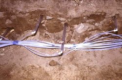
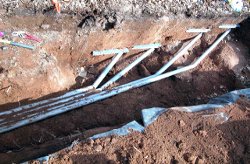
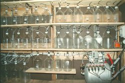
Vertical drainage is difficult to measure accurately and is not routinely performed on experimental sites. Tools such as lysimeter plates (which collect free water using gravity) or porous tubes (water extraction via vacuum) exist for measuring drainage water and are used to collect samples at different depths in the soil for chemical analysis.


Collection of soil water through porous tubes (left) and lysimeter plates being installed in the soil (right). The soil solutions are collected in bottles (below)
 However, these devices do not provide quantitative measurements of drainage flow, mainly because the magnitude
of the collection area is unknown: in a given soil horizon, this area may be larger or smaller than the surface of the plate.
Our approach is to calculate drainage by the difference (see the page Water Balance) between incident rainfall and actual
evapotranspiration. Like the other water fluxes, the flow of drainage water is expressed in mm (1 mm = 1 L / m²).
How is this water flow controlled?
Water flow or drainage flow corresponds to varying rates of displacement of free water in the soil.
Two situations are possible :
- The soil moisture is at field capacity. All of the water reaches the top of a soil layer resulting in an output equal to that of the water input. If this flow is blocked (e.g. clay soil layer), the water will accumulate to form a water table.
- The soil moisture is below field capacity. Water flowing in through the top of a horizon follows two paths with two different time constants: part of the water will rapidly seep downwards into the soil macropores, while the complementary fraction will rehydrate the soil layer through the macropores and the micropores.
What are the temporal variations?
Drainage can occur throughout the year through the processes described above. Drainage is naturally higher during periods of heavy rainfall. At its maximum, drainage will equal incident rainfall (when the soil is at field capacity and when there is no transpiration). Refer to the page Water balance modelling for more information on calculating drainage in the soil layers.
What are the spatial variations?
Little quantitative information is available on this issue to date, but we do know that from the decimetre scale, significant spatial variability in drainage exists relative to soil texture, structure, bulk density heterogeneities and as such, variability in soil porosity.
A few key figures
We performed simulations in a temperate climate over the course of a wet year and a dry year, in three forest types: coniferous, deciduous with high leaf index and deciduous with low leaf area index:
| drainage (in mm) wet year (2002, 1158 mm) |
drainage (in mm) dry year (1996, 676 mm) | |
|---|---|---|
| coniferous | 536 | 215 |
| deciduous high LAI | 557 | 237 |
| deciduous low LAI | 586 | 247 |
Useful references
![]() Ballif JL, Dutil P (1983) Lysimétrie en sol de craie non remanié. I - Drainage, évaporation et rôle du
couvert végétal. Résultats 1973-1980. Agronomie, 3, 857-866.
Ballif JL, Dutil P (1983) Lysimétrie en sol de craie non remanié. I - Drainage, évaporation et rôle du
couvert végétal. Résultats 1973-1980. Agronomie, 3, 857-866.
![]() Badeau V, Ulrich E (2008) RENECOFOR - Etude critique de faisabilité sur : la comparabilité des données météorologiques « RENECOFOR » avec
celles de Météo France, l’estimation de la réserve utile en eau du sol et le calcul des volumes d’eau drainée en vue du calcul de bilans
minéraux sur les placettes du sous-réseau CATAENAT. Editeur : Office National des Forêts, Direction Technique et Commercial Bois,
ISBN 978 – 2 – 84207 – 323 – 7, 108 p. et 166 pages annexes.
Badeau V, Ulrich E (2008) RENECOFOR - Etude critique de faisabilité sur : la comparabilité des données météorologiques « RENECOFOR » avec
celles de Météo France, l’estimation de la réserve utile en eau du sol et le calcul des volumes d’eau drainée en vue du calcul de bilans
minéraux sur les placettes du sous-réseau CATAENAT. Editeur : Office National des Forêts, Direction Technique et Commercial Bois,
ISBN 978 – 2 – 84207 – 323 – 7, 108 p. et 166 pages annexes.
![]() Beven K, Germann P (1982) Macropores and Water Flow in Soils. Water Resources Research, 18 (5), 1311-1325.
Beven K, Germann P (1982) Macropores and Water Flow in Soils. Water Resources Research, 18 (5), 1311-1325.
![]() Klinge R, Schmidt J, Fölster H (2001) Simulation of water drainage of a rain forest and forest conversion plots using a
soil water model. Journal of Hydrology, 246, 82-95.
Klinge R, Schmidt J, Fölster H (2001) Simulation of water drainage of a rain forest and forest conversion plots using a
soil water model. Journal of Hydrology, 246, 82-95.
![]() Minderman G, Leeflang K W F (1968) The amount of drainage water and solutes from lysimeters planted with either oak, pine or natural
dune vegetation, or without any vegetation cover. Plant and Soil, XXVIII, n°1 February 1968, 61-80.
Minderman G, Leeflang K W F (1968) The amount of drainage water and solutes from lysimeters planted with either oak, pine or natural
dune vegetation, or without any vegetation cover. Plant and Soil, XXVIII, n°1 February 1968, 61-80.

