BILJOU
Forest water balance model
 - Silva Joint Research Unit
WELCOME
BILJOU© is a forest water balance model developed by the joint research unit Ecology and Forest Ecophysiology, now the
Joint Research Unit Silva,
a collaborative project between INRAE, AgroParisTech and the University of Lorraine.
The BILJOU© model is a research tool available to the international community of forest managers, teachers, students and researchers. We have designed BILJOU© to offer integrated online simulation and a continuously evolving, robust set of solutions aimed at furthering our understanding the mechanisms driving interactions between forest ecosystems and their climatic and edaphic environments.
The BILJOU© model is limited to non-commercial use only (see license restrictions).
The first version of this site was initially developed as part of the project Joint Technological Network
AFORCE with support funding from GIP ECOFOR.
A second version with new functionalities and an English version was made possible by the laboratory of excellence,
Labex ARBRE.
The web mapping facilities on line from the first time in 2017 sign the third version and were made possible by the Forest health Department of the French ministry for agriculture and food cares about and forest.
The fourth version of the site, online in the first half of 2022, consists of a major technical evolution in response to technical developments and compliance with the RGPD: the online calculation tool has been recoded, in French and English, the mapping facilities has been upgraded, the user license has been modified, and the bibliographic references have been enriched. These evolutions were funded by the INRA AAFCC metaprogram.
The national maps of drought events in forests exposed to future climates enhance the fourth version, developed within the framework of an initiative for the development of climate services for agriculture and forestry, supported by the INRA AAFCC metaprogram. Its creation was co-funded by the FORET-21 project of the French Ministry of Agriculture, Food and Forestry, within the framework of its "Innovation and investments for upstream forestry” program. The implementation of this fifth version is scheduled during 2022.
 News and updates
07/2022...the version 4 is online!
In addition to the technical upgrades that required a complete recoding of the site, this new version offers an upgraded online service for consulting drought indicator maps of metropolitan France.
br/>
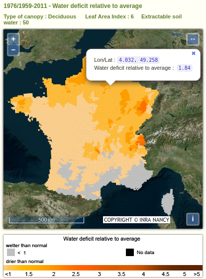
These maps have been pre-calculated using the BILJOU© model by UMR SILVA for the SAFRAN archive from 1959 to 2019 and for a number of stands and soil types, homogeneous type on the whole metropolitan territory.
More than 70,000 pre-calculated maps with a regular grid of 8x8 km can be dynamically generated and visualized online thanks to a query form.
Warning: In this version 4, the maps do not represent the actual spatial distribution of soils, deciduous or evergreen stands. The maps are merely an assistance in geolocalizing the user's query and quantifying the impact of the geographic variability of annual and average meteorology alone.
Discover drought indicators maps

01/2017...the version 3 is now up and running!
In addition to the corrections made to existing features in version 2, this new version offers a map online service for drought indicators of metropolitan France.
These maps have been pre-computed using the model BILJOU© by UMR Forest Ecology and Ecophysiology for historical climate record from 1950 to 2011 and for a number of stands and soil type .
More than 40 000 maps to the regular grid 8x8 km have been produced and are available online by a specific query form.
The maps from 2012 to today are being prepared and will soon be available.
Discover drought indicators maps
03/2015...the version 2 is now up and running!
Adding full translation of the web site in
both French and in English.
We have also added a new information page dedicated to blue and
green water to illustrate interactive relationships that occur between
ecosystem services provided by forests.
New special functions added to the BILJOU © 2 application:
- Calculating potential evapotranspiration (PET) using the FAO Penman-Monteith method independently from relative humidity or atmospheric saturation deficit.
- Modeling rainfall interception using leaf area index and precipitation rates.
- Calculating PET using the Penman-Monteith method using the duration of bright sunshine in the absence of global solar radiation (the sum of direct, diffuse and reflected solar radiation), which is often the case when using older data. For this functionality, the tool requires geographic coordinates and site altitude.

New graphics for representing variables:
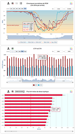
- Actual evapotranspiration (AET), Potential evapotranspiration (PET).
- A classified representation of the years of drought using three indicators: water deficit, the duration and the magnitude of the deficit.
- A new mode for representing daily measurements taken over several years.
Fully updated graphics designed for intuitive functionality:
- Dynamic and interactive graphs with floating text boxes and time zoom control.
- New options for comparing data between given years with overlaying data curves on intra-annual graphs for more precise analysis.
- Statistics (average or median variables) can now be displayed on request for each graphic.
The simulations dashboard has also been enhanced to allow you to track your simulation calculations and offers new features.
09/2010...the first version is now up and running!
It offers an online course on the water balance of forests and access to an online calculation tool BILJOU ©, until now reserved for scientific use. This tool allows any user to make his own calculations for his stands from the soil characteristics of the soil, canopy and a meteorological data file.
Our aim was to create a fully comprehensive and informative website focused on forest water balance, on
the impact of fresh water fluxes that exist in forest ecosystems and the factors that cause their variation.
Our site also offers access to the dynamic online modeling tool BILJOU© with clear explanations for fast and efficient user interface. BILJOU© offers interactive simulation modeling from uploaded input data to calculate daily and annual results.
In addition to output files, BILJOU© offers graphic modules to visualize simulated temporal variations in water fluxes (evapotranspiration, drainage) as well as drought indicators (duration and intensity of water deficit).
Please feel free to contact us with any comments or suggestions about our site or the BILJOU© modeling tool. We welcome your feedback.


